top of page
Adams Antiques & the Potager
Fine European Antiques for the Home & Garden Est. 1976

APMS285*
Antique French Geographie Moderne maps mounted on wood puzzles circa 1870
3 in stock
12"x17"
$175 each
3 in stock
12"x17"
$175 each

IMGAFEM418*
Antique French map engravings from "L'Univers. Atlas Classique Et Universel De Geographie Ancienne Et Moderne" by M. Monin circa 1837
Plate Size 19"x14"
20 in stock
$225 each
Plate Size 19"x14"
20 in stock
$225 each

ADLG222*
Antique French maps from Atlas De La Geographie Ancienne, Du Moyen Age, et Moderne by Felix Delamarche circa 1830s
Plate Size 12"x17"
51 in stock
$225 each
Plate Size 12"x17"
51 in stock
$225 each

AFAM471*
Antique French hand colored copper engraving maps from atlas "Universel de Geographie Physique et Politique" by E. Mentelle and P. Grégoire Chanlaire circa 1797
Plate Size 18"x13.5"
33 in stock
$250 each
Plate Size 18"x13.5"
33 in stock
$250 each

AUAT499*
Antique French hand colored maps from "Atlas Geographie Moderne" By J. Andriveau & Goujon circa 1850
Plate Size 20"x16"
13 in stock
$225 each
Plate Size 20"x16"
13 in stock
$225 each

AGMP744*
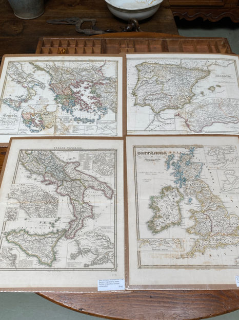
Antique German maps printed in Italian from "Atlas Antiquus Delineavit Dr. C. de Spruner" Engravings by Justus Perthes circa 1850
Plate Size 13"x15"
32 in stock
$195 each
Plate Size 13"x15"
32 in stock
$195 each

15_621BDD
Antique French map with watercolor details of a coastal fortification and land lots in gilt frame
22"x17.5"
$260
22"x17.5"
$260

05042018_11CEDD
Large Antique French map of Asia circa 1821 lined with linen & mounted on oak rods
50"x37.5"
$800
50"x37.5"
$800

AEEM577
Antique English hand colored engraved maps from "The World-Wide Atlas of Modern Geography" By J. Scott Keltie circa 1898-1901
Page Size 9.25"x12"
13 in stock
$50 each
Page Size 9.25"x12"
13 in stock
$50 each

HCA96
Antique French Bourgogne region hand colored land use maps backed with linen from Atlas L'Hospice des Malades
circa 1851
39"x25"
27 in stock
$495 each
circa 1851
39"x25"
27 in stock
$495 each

HCA92
Antique French Bourgogne region hand colored land use maps backed with linen from Atlas L'Hospice des Malades
circa 1851
19.5"x25"
12 in stock
$295 each
circa 1851
19.5"x25"
12 in stock
$295 each

AFEM318
Antique French map engravings from "L'Univers. Atlas Classique Et Universel De Geographie Ancienne Et Moderne" by M. Monin circa 1837
30"x22"
3 in stock
$325 each
30"x22"
3 in stock
$325 each

AEAM359
Antique English hand colored map engravings from Samuel Butler's "An Atlas of Modern Geography" circa 1822
Page Size 8.5"x11"
10 in stock
$75 each
Page Size 8.5"x11"
10 in stock
$75 each

PLDD2222
PLDD2222
Antique French color lithograph map prints from the encyclopedia "Nouveau Larousse Illustre" circa 1898-1904
Page size 9"x12"
66 in stock
$20 each
Antique French color lithograph map prints from the encyclopedia "Nouveau Larousse Illustre" circa 1898-1904
Page size 9"x12"
66 in stock
$20 each

ABFM299*
Antique French hand colored maps prints attributed to Georges Buffon circa 1845
4 in stock
Plate size 5.5"x7"
$75 each
4 in stock
Plate size 5.5"x7"
$75 each

AFGM260
Antique French hand colored maps from "Geographie Moderne" by De E. Cortambert circa 1863
Plate Size 12"x9.5"
37 in Stock
$75
Plate Size 12"x9.5"
37 in Stock
$75

AFMS269
Antique French hand colored maps by A. Vuillemin circa 1840
Plate Size 10.5"x8"
30 in Stock
$85 each
Plate Size 10.5"x8"
30 in Stock
$85 each

AFGM174
Antique French maps from "Stielers Hand Atlas" H.Habenicht, Gotha, J. Perthes circa 1880-1920
Plate size 17"x14"
146 in stock
$45 each
Plate size 17"x14"
146 in stock
$45 each

AFMP059
Antique French maps from "Geographie Universelle Atlas" by Migeon & Vuillemin circa 1870s
plate size 17"x13"
7 in stock
$75 each
plate size 17"x13"
7 in stock
$75 each

FNA264
Antique French hand colored territories & resources maps from Atlas National Illustre circa 1860
plate size 18"x12.5"
152 in stock
$95 each
plate size 18"x12.5"
152 in stock
$95 each

LFMP834
Antique French hand colored maps from Migeon Atlas "La France Et Ses Colonies By Alexandre Vuillemin circa 1850s
Plate size 9"x11"
96 in stock
$45 each
Plate size 9"x11"
96 in stock
$45 each

Antique German chromolithograph map prints from the encyclopedia "The Meyers Großes Konversations-Lexikon" circa 1890-1910
Page Size 12"x9.5"
54 in stock
$20 each
Page Size 12"x9.5"
54 in stock
$20 each

ADLG223
Antique French hand colored maps from Atlas De La Geographie Ancienne, Du Moyen Age, et Moderne by Felix Delamarche circa 1841
13"x18"
31 in stock
$195 each
13"x18"
31 in stock
$195 each

AUEC783
Antique French colored maps from "Atlas Universel et Classique de Geographie" by MM Drioux CH Leroy circa 1886

bottom of page